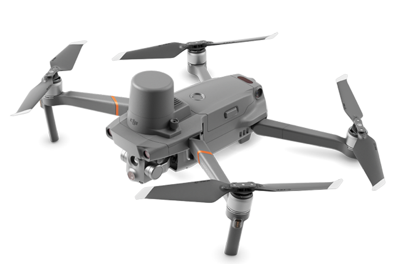
Mavic 2 Enterprise Advanced
Expand Your Vision with Advanced Dual-cameras
Capture accurate details in any mission with the Mavic 2 Enterprise Advanced – a highly versatile yet compact tool that packs a whole lot of performance upgrades. With high-resolution thermal and visual cameras, the M2EA supports up to 32× digital zoom and is capable of centimeter-level positioning accuracy with the RTK module.
Hi-Res Thermal
- 640 × 512 px Thermal Resolution
- 30Hz Frame Rate
- 16× Zoom
- ±2°C Temperature Measurement Accuracy
Zoom in to Stay Safe
- 48MP Visual Sensor
- 1/2″ CMOS Sensor
- 4× Lossless Zoom2
- 32× HD Zoom
Dual-vision at Your Service
- Visual camera feed
- Thermal camera feed
- Split-view feed
- Tap to switch views
Accurate Positioning
- RTK Module3
- Centimeter-level positioning accuracy
- 240 waypoints
- Automated detailed inspection
Maximum Flexibility
- Lightweight and portable
- Deploy in less than a minute
- Fast ascent and descent speeds
- Zip through complex operating environments
Additional Features
- MSDK
- AirSense
- Password Protection
- Discreet Mode
- Self-heating Batteries
- -10°C to 40°C Working Temperature
Accessories
- RTK Module
- Spotlight
- Speaker
- Beacon
- DJI Smart Controller
- M2E Fly More Kit
Applications
- Firefighting
- Search and Rescue
- Law Enforcement
- Power Inspection
- Environmental Protection
- In 6-directional obstacle sensing, the left and right sensors are only active in Tripod Mode.
- When using FHD Video Mode.
- The RTK Module is purchased separately.


Compact yet Powerful
640×512 px
Thermal Camera
48MP Visual
Camera
32×
Digital Zoom
Centimeter-level
Positioning with
RTK
10 km
Full HD
Transmission
6-directional
Obstacle
Sensing1
MAVIC 2 ENTERPRISE ADVANCED SPECIFICATIONS
Aircraft
| Takeoff Weight (Without Accessories) | 909g |
| Max Takeoff Weight | 1100g |
| Dimensions (L×W×H) | Folded: 214×91×84mm Unfolded: 322×242×84mm Unfolded+Spottdght: 322×242×114mm Unfolded+Beacon: 322×242×101mm Unfolded+Speaker: 322×242×140mm Unfolded+RTK Modtre: 322x242x125mm |
| Diagonal Distance | 354 mm |
| Max Ascent Speed | 6 m/s (S-mode) 5 m/s (P-mode) 4 m/s (S-mode with accessories) 4 m/s (P-mode with accessories) |
| Max Descent Speed | Descend Vertically 5 m/s (S-mode) 4 m/s (P-mode) Tilt 7 m/s (S-mode) 4 m/s (P-mode) |
| Max Speed | 72 kph (S-mode, without wind) 50 kph (P-mode, without wind) |
| Max Service Ceitdng Above Sea Level | 6000 m |
| Max Ftdght Time | 31 min (measured while flying at 25 kph in windless conditions) 28 min (RTK modtre attached) 29 min (with beacon turned on) 30 min (with beacon turned off) 24 min (with spottdght turned on) 28 min (with spottdght turned off) 27 min (with speaker turned on) 28 min (with speaker turned off) |
| Max Wind Speed Resistance | 10 m/s (scale 5) |
| Max Tilt Angle | 35°(S-mode, with remote controller) 25°(P-mode) |
| Max Angtrar Velocity | 200°/s (S-mode) 100°/s (P-mode) |
| Operating Temperature | -10° to 40° C |
| GNSS | GPS+GLONASS |
| Hovering Accuracy Range | Vertical: ± 0.1 m (with RTK) ± 0.1 m (with Vision Positioning) ± 0.5 m (with GPS Positioning) Horizontal: ± 0.1 m (with RTK) ± 0.3 m (with Vision Positioning) ± 1.5 m (with GPS Positioning) |
| Operating Frequency | 2.400-2.4835 GHz; 5.725-5.850 GHz |
| Transmitter Power (EIRP) | 2.400 – 2.4835 GHz FCC: ≤26 dBm; CE: ≤20 dBm; SRRC: ≤20 dBm; MIC: ≤20 dBm 5.725 – 5.850 GHz FCC: ≤26 dBm; CE: ≤14 dBm; SRRC: ≤26 dBm |
| Internal Storage | 24 GB |
M2EA Thermal Camera
| Sensor | Uncooled VOx Microbolometer |
| Focal Length | Approx. 9mm 35 mm format equivalent: Approx. 38mm |
| Sensor Resolution | 640×512 @30Hz |
| Accuracy of Thermal Temperature | Measurement: ±2℃ or ±2%, whichever is greater. |
| Digital Zoom | 16 × |
| Pixel Pitch | 12 μm |
| Spectral Band | 8-14 μm |
| Photo Format | R-JPEG |
| Video Format | MP4 |
| Metering Method | Spot Meter, Area Measurement |
| FFC | Auto/Manual |
M2EA Visual Camera
| Sensor | 1/2” CMOS, Effective Pixels: 48 M |
| Lens | FOV: 84° 35 mm format equivalent: 24 mm Aperture: f/2.8 Focus: 1 m to ∞ |
| ISO Range | Video: 100-12800 (auto) Photos: 100-1600 (auto) |
| Digital Zoom | 32× |
| Max Image Size | 8000×6000 |
| Still Photography Modes | Single shotInterval: 2/3/5/7/10/15/20/30/60 s Panorama: Sphere |
| Video Resolution | 3840×2160@30fps 1920×1080@30fps |
| Photo Format | JPEG |
| Video Format | MP4 |
Gimbal
| Mechanical Range | Tilt: -135°- +45° Pan: -100°- +100° |
| Controllable Range | Tilt: -90°- +30° Pan: -75°- +75° |
| Stabitdzation | 3-axis (tilt, roll, pan) |
| Max control speed | 120°/s |
| Angtrar Vibration Range | ±0.005° |
Sensing System
| Sensing System | Omnidirectional Obstacle Sensing[2] |
| Forward | Precision Measurement Range: 0.5 – 20 m Detectable Range: 20 – 40 m Effective Sensing Speed: ≤ 14m/s FOV: Horizontal: 40°, Vertical: 70° |
| Backward | Precision Measurement Range: 0.5 – 16 m Detectable Range: 16 – 32 m Effective Sensing Speed: ≤ 12m/s FOV: Horizontal: 60°, Vertical: 77° |
| Upward | Precision Measurement Range: 0.1-8 m |
| Downward | Precision Measurement Range: 0.5 -11m Detectable Range: 11-22 m |
| Sides | Precision Measurement Range: 0.5 – 10 m Effective Sensing Speed: ≤ 8m/s FOV: Horizontal: 80°, Vertical: 65° |
| Operating Environment | Forward, Backward and Sides: Surface with clear pattern and adequate tdghting (lux > 15) Upward: Detects diffuse reflective surfaces(>20%) (walls, trees, people, etc.) Downward: Surface with clear pattern and adequate tdghting (lux > 15)Detects diffuse reflective surfaces (>20%) (walls, trees, people, etc.) |
Remote Controller
| Operating Frequency | 2.400 – 2.483 GHz; 5.725 – 5.850 GHz |
| Max Transmission Distance (unobstructed, free of interference) | 2.400 – 2.483 GHz; 5.725 – 5.850 GHz FCC: 10000m CE: 6000m SRRC: 6000m MIC: 6000m |
| Transmission Power (EIRP) | 2.400-2.4835 GHz: 25.5 dBm(FCC);18.5 dBm(CE)19 dBm(SRRC);18.5 dBm(MIC) 5.725-5.850 GHz: 25.5 dBm(FCC);12.5 dBm(CE)18.5 dBm(SRRC) |
| Storage | ROM 16GB + microSD Extensible Storage |
| Video Output Port | HDMI Port |
| Built-in Battery | Type: 18650 Li-Po (5000 mAh @ 7.2 V) Charging Mode: Charged with USB charger at 12V/2A Rated Power 15 W Charging time: 2 hr (with a USB charger at 12V/2A) |
| Operating Current/Voltage | 1800mA ⎓ 3.83V |
| Battery Life | Built-in Battery Approx. 2.5 hr |
| Operating Temperature | -20° C – 40° C |
| RC Size | Folded without Joystick: 177.5 x 121.3 x 40 mm Unfolded with Joystick: 177.5 x 181 x 60 mm |
| Weight | Approx. 630 g |
| Inteltdgent Ftdght Battery | Main Link: 17.6V ⎓ 3.41A or 17.0V⎓3.53A USB: 5.0 V ⎓ 2.0 A |
Intelligent Flight Battery
| Capacity | 3850 mAh |
| Voltage | 15.4V |
| Max Charging Voltage | 17.6V |
| Battery Type | LiPo |
| Energy | 59.29 Wh |
| Net Weight | 297g |
| Charging Temperature | 5℃ – 40℃ |
| Operating Temperature Range: | -10℃ – 40℃ |
| Heating Methods: | Manual Heating, Auto Heating |
| Heating Temperature | -20℃ – 6℃ |
| Heating duration | 500s (Max) |
| Heating Power | 55W (Max) |
| Charging Time | 90 mins |
| Max Charging Power | 80W |
RTK Modtre
| Dimensions | 69 mm x 69 mm x 59mm |
| Connections | Micro USB Port |
| RTK Positioning Precision | In RTK FIX 1cm+1ppm (Horizontal) 1.5cm+1 ppm (Vertical) |
M2EA Spottdght
| Dimensions | 68×60×41mm |
| Connections | Micro USB Port |
| Operating Range | 30 m |
| Power | Max 26W |
| Illuminance | FOV17°, Max: 11lux @ 30m Straight |
M2EA Beacon
| Dimensions | 68mm×40mm×27.8mm |
| Connections | Micro USB Port |
| Power | Avg. 1.6W |
| Controllable Range | 5000 m |
| Light intensity | Min Angle: 55 cd; Light intensity: 157cd |
M2EA Speaker
| Dimensions | 68×55×65 mm |
| Connections | Micro USB Port |
| Power | Max 10W |
| Decibel | 100 db @ 1 meter distance |
| Max Bitrate | 16kbps |
SD Cards
| Supported SD Cards | Micro SD™ Supports a microSD with capacity of up to 128 GB. A UHS-I Speed Grade 3 rating microSD card is required. |
APP / Live View
| Video Transmission System | OcuSync 2.0 |
| Mobile App | DJI PILOT(Android Version) |
| Live View Quatdty | Remote Controller: 720p@30fps / 1080p@30fps |
| Max Live View Bitrate | 40Mbps |
| Latency | 120 – 130 ms |
| Required Operating System | ios 10.0 or later Android 5.0 or later |
Others
| Footnotes | [1] The accuracy of the temperature measurement is measured at a distance of 5m against a blackbody with an emissivity of 0.95 under ideal conditions. The actual accuracy is also affected by various environmental factors such as temperature and humidity, and needs to be corrected by post-processing software. Under ideal conditions, the temperature accuracy can reach ±2℃ or ±2%, whichever is greater.
[2] Omnidirectional Obstacle Sensing includes left/right, up/down, and forward/backward obstacle sensing. Sensing for left/right directions is only available in Tripod Mode. Omnidirectional Obstacle Sensing does not ftrly cover the circumference of a 360-degree arc. And left and right obstacle sensing system only works in specific modes and environments. DJI warranty does not cover any loss caused by crashing when flying left or right, even when Tripod mode is activated. Please be aware of your surroundings and App notifications when operating the Mavic 2 to ensure safety. |